3種のプレート境界、3枚の断面、1つのプロンプト——これは地球科学からAIイラストへの贈り物です。大きな構造、安定した語彙、定型のレイアウト。以下は20のプロンプトで、構造・火山・地形過程・水循環・岩石循環をカバーし、それぞれにラベルと確認すべき事実を付けます。
地球科学プリセットを開く · ワークフロー完全版 · 実例30選
授業メモ:地学の地形断面、水循環、岩石圏の物質循環はこのパックの射程内です。プロンプトは英語のまま(図中ラベルは英語大文字が最も安定)。
プレートテクトニクス
1. 3種の境界
A triple cross-section comparison of tectonic boundaries: divergent plates pulling
apart with rising magma, convergent subduction with trench and volcanic arc, and
transform plates grinding past each other with a fault line. Label "DIVERGENT",
"CONVERGENT", "TRANSFORM", "SUBDUCTION", "RIFT". Title: "BOUNDARY TYPES".
確認:トランスフォームのパネルは水平なずれを示すこと——道路、柵、河川が断層で食い違う描画。
2. 沈み込み帯の解剖
A detailed subduction cross-section: oceanic plate bending into the trench, slab
descending into the mantle, water released triggering melt, magma rising through
the overriding plate to a volcanic arc, and earthquake-depth dots coloring the
slab. Label "TRENCH", "SLAB", "DEWATERING", "MAGMA", "VOLCANIC ARC".
Title: "THE SINKING FLOOR".
確認:地震の深さ点はスラブとともに深くなる(和達ベニオフ面)。火山弧は海溝の内陸側。

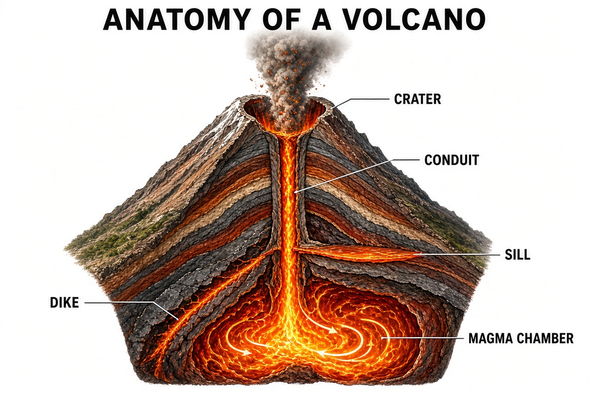
3. 火山の内部構造
A stratovolcano cutaway from crater to magma chamber: layered lava and ash strata,
central conduit, branching dike and horizontal sill, and convection swirls within
the chamber, eruption column above. Label "CRATER", "CONDUIT", "DIKE", "SILL",
"MAGMA CHAMBER". Title: "ANATOMY OF A VOLCANO".
確認:岩脈は地層を切って走り、シルは層に沿って——この図が教えるために存在する区別です。
地形過程
4. 氷河の運動と堆石
A valley-glacier figure in three layers: surface crevasses, internal flow lines
faster at the center, and basal till deforming beneath; lateral and terminal
moraines forming at the edges and snout, with a mass-balance inset.
Label "CREVASSE", "FLOW LINE", "BASAL TILL", "LATERAL MORAINE", "TERMINAL
MORAINE". Title: "RIVERS OF ICE".
確認:流動は中央上部が最速、側壁と氷床で最遅。クレバスは表面にあり内部ではない。

5. 河川デルタの類型
A comparative geomorphology figure of three delta shapes: bird-foot delta with
extending fingers, arcuate delta with smooth bow, and estuarine delta drowned in
a funnel, each with wave, tide and river-force arrows sized by dominance.
Label "BIRD-FOOT", "ARCUATE", "ESTUARINE", "WAVES", "TIDES".
Title: "DELTA SHAPES".
確認:鳥足型=河川優勢(ミシシッピ)、弧状=波浪の影響、河口湾型=潮汐優勢——矢印の大きさと形の対応。

6. 鍾乳洞の形成過程
A karst cross-section story: rainwater absorbing carbon dioxide, percolating
through limestone joints, enlarging them into caverns, stalactite and stalagmite
growth zones, and a collapsed sinkhole stage. Label "JOINTS", "CAVERN",
"STALACTITE", "STALAGMITE", "SINKHOLE". Title: "STONE AND WATER".
確認:鍾乳石は天井から垂れ、石筍は床から立つ。生成の順序は水の動きに従う。

7. 永久凍土融解のフィードバック
A permafrost feedback figure: warming ground thawing the active layer, ice lenses
melting into thermokarst ponds, trapped methane bubbling out, and the released
greenhouse gases feeding further warming in a loop-back arrow. Label "ACTIVE
LAYER", "THERMOKARST", "METHANE", "FEEDBACK". Title: "THE THAW LOOP".
確認:ループは閉じること——温暖化に戻らないフィードバック矢印はフィードバックではない。
2大サイクル
8. 水循環
A full water-cycle plate: solar energy driving evaporation from ocean and lakes,
transpiration from plants, condensation into clouds, precipitation over mountains,
surface runoff joining rivers, infiltration to groundwater, and the ocean as both
start and end. Label "EVAPORATION", "TRANSPIRATION", "CONDENSATION",
"PRECIPITATION", "INFILTRATION". Title: "THE WATER CYCLE".
確認:すべての矢印が重力かエネルギーに従う——流出は下り、蒸発は上り。蒸散は植物に付き、水面ではない。
9. 岩石循環
A rock-cycle diagram: magma crystallizing to igneous rock, weathering and erosion
to sediment, compaction into sedimentary rock, heat and pressure to metamorphic
rock, and melting back to magma, with uplift arrows connecting surface and depth.
Label "IGNEOUS", "SEDIMENT", "SEDIMENTARY", "METAMORPHIC", "MELTING".
Title: "THE ROCK CYCLE".
確認:矢印は状態を飛ばせる(堆積岩→変成岩の直行)が、エントロピーをただで逆転させない——堆積物は融解なしにマグマにならない。
10. 土壌断面と侵食
A soil-profile figure beside its forming processes: a soil column with O, A, B and
C horizons over bedrock, with raindrop impact, roots, and burrowing organisms
annotated, and a downslope erosion arrow removing A-horizon material.
Label "O HORIZON", "A HORIZON", "B HORIZON", "C HORIZON", "BEDROCK".
Title: "SOIL STORIES".
大気と空
11. 雲の分類
A meteorological plate of the ten principal cloud genera arranged by altitude
band: high cirrus family, mid alto group, low stratus family, and vertical
cumulus column, each cloud with its altitude label. Label "CIRRUS",
"ALTOCUMULUS", "STRATUS", "CUMULONIMBUS". Title: "READING THE SKY".
確認:乱層雲の配置が頻出ミス——中〜低層にまたがる。積乱雲は層を垂直に貫く。

12. オーロラのメカニズム
An aurora mechanism figure: solar wind particles funneled by Earth's magnetic
field toward the polar ovals, collisions in the upper atmosphere exciting oxygen
and nitrogen, and the resulting green and red curtains seen from the ground,
plus a height-versus-color scale. Label "SOLAR WIND", "MAGNETIC FIELD", "OXYGEN",
"NITROGEN". Title: "SKY ON FIRE".
10のクイックバリエーション
| # | トピック | 一行変更 |
|---|---|---|
| 13 | 流域 | "A watershed map-style figure with drainage divides, tributaries joining a main river… Label 'DIVIDE', 'TRIBUTARY', 'FLOODPLAIN'" |
| 14 | 地下水 | "A cross-section with water table, saturated zone, wells and a cone of depression… Label 'WATER TABLE', 'SATURATED ZONE', 'RECHARGE'" |
| 15 | 沿岸漂砂 | "A coastline plan view with waves striking at an angle and sediment moving alongshore… Label 'LONGSHORE DRIFT', 'SPIT'" |
| 16 | 地温勾配 | "A borehole cross-section with temperature increasing with depth… Label 'GEOTHERMAL GRADIENT', 'CRUST', 'MANTLE'" |
| 17 | 炭素循環 | "A four-reservoir carbon cycle: atmosphere, biosphere, ocean, geosphere… Label each flux" |
| 18 | ハドレー循環 | "A meridional circulation cross-section of Earth's atmosphere with rising equatorial air and descending subtropical air… Label 'HADLEY CELL', 'ITCZ'" |
| 19 | 地溝帯の形成 | "Three-stage continental rifting: dome, graben, nascent sea… Label 'DOME', 'GRABEN', 'RIFT VALLEY'" |
| 20 | 化石の保存 | "Four modes of fossil preservation: permineralization, cast, mold, amber… Label each" |
よくある質問
AIの断面図は信頼できますか?
構造と関係は——層序、岩脈の切断、弧のオフセット——はい。プロンプトが強制できる構成の事実だからです。正確な深さと厚さはいいえ。数字が重要なら、自分の注記か専門ツールに入れます。生成断面は「概念的に正確、測定的には概略」として扱ってください。
地球科学では矢印がなぜ特別に重要ですか?
この分野の半分はフラックスと方向だからです——水が循環し、プレートが収束し、エネルギーが天気を駆動する。矢印の違う美しい静止画は、間違ったモデルを教えます。すべての矢印を参考文献と照合してトレースすること。ライフサイクルガイドの第1チェックも同じ理由です。
地質年代はどう誠実に示しますか?
縮尺どおりに——ではなく、そう明記します。"five stages, not to scale, with a relative-time note" は、でたらめな比率のタイムラインに勝ります。順序が期間より重要なら段階パネルで、期間自体が主題なら本物のチャートツールで。AI図は過程を担当します。
平面図と断面図、どちらが上手ですか?
断面粉です。語彙(地層、貫入、切り取り)がモデルの得意と重なるため。実在の地理を含む平面図は弱い——海岸線と位置はまさに「精密幾何」の類で、専門ツールの領域です。物理工学ガイドが機械の側から同じ境界を引いています。
地学の授業で使う順番のおすすめは?
まず3種の境界(構造の対比)→成層火山(岩脈とシルの区別)→水循環(矢印の監査)の順で3枚作ると、断面の読み方・方向の確認・循環の閉合という本ガイドの3つの技術を1単元で練習できます。いずれも6ラベル以内に収め、教科書の図と見開きで照合してください(教師向けガイド)。
検証チェックリスト
- [ ] すべてのラベルのつづりは正しいか?
- [ ] 指定した構造はすべて描かれているか?
- [ ] 断面で各層の深さ方向の順序は正しいか?
- [ ] 矢印は正しい方向か(下り坂、風下、下流)?
- [ ] サイクルは閉じ、段階は正しい順序か?
- [ ] 信頼できる情報源と照合したか?